Europeana Social
 Interactive timelines & maps, GIFs, voiceover videos, AR experiences - there are so many ways to tell a fascinating #CulturalHeritage story. Explore our resources and tutorials and find inspiration for your #DigiStoryFest contest submission ➡️https://bit.ly/3awuZSj https://t.co/vdqigFccy9
by @Europeanaeu | 1 year ago
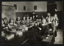 Stacks of chalks, wooden benches, colourful maps on the wall: these vintage classrooms paint a vivid picture of what school days used to be like before digital blackboards and remote teaching came into play. Explore our #BackToSchool gallery ➡️https://bit.ly/2Ru19Bj https://t.co/casbb7OxY7
by @Europeanaeu | 2 years ago
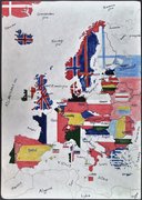 For centuries, cartographers and others have defined Europe, its lands and borders through maps. Explore a variety of interesting maps from across history in our #GalleryOfTheWeek➡️ https://bit.ly/2Elrxu7 #DiscoveringEurope https://t.co/ZeXXRIEPR3
by @Europeanaeu | 3 years ago
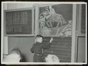 Stacks of chalks, wooden benches, colourful maps on the wall: these vintage classrooms paint a vivid picture of what school days used to be like before digital blackboards and remote teaching came into play. Explore the gallery ➡️ https://bit.ly/2Ru19Bj #CenturyOfChange https://t.co/69118A7Yuu
by @Europeanaeu | 3 years ago
 "The grant has allowed me to produce a resource that processes #WWI postcards in a form that maps their movements in time, while retaining a presence on the map itself" - read the interview with Europeana Research Grant Winner @Zaziegazouillehttp://bit.ly/2JtxQLN https://t.co/sPwG1HUC3H
by @Europeanaeu | 4 years ago